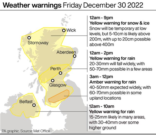
Weather warnings for rain, snow and ice have been issued across Scotland on Friday.
A Met Office amber alert for heavy rain has been issued for rain in parts of Dumfries and Galloway as well as the Scottish Borders.
Weather forecasters have warned residents to expect around 40-50mm of rain around the area. Fast-flowing or deep floodwater is also expected which could cause danger to life.
A yellow warning for rain is in place in much of the central belt and southern parts of Scotland.
Amber warning of rain affecting Dumfries, Galloway, Lothian & Borders https://t.co/URD0hb4W6Q pic.twitter.com/4chB8MESA8
— Met Office – SW Scotland (@metofficeSScot) December 29, 2022
Yellow warnings for snow and ice are also in place across much of the north of Scotland. Some roads and railways will be affected with longer journey times by road, bus and train services.
There will also be icy patches on some untreated roads, pavements and cycle paths, the Met Office says.
The amber alert will be in place from midnight on Thursday until 2pm on Friday with yellow alerts being in place until 9pm.
Motorists have been warned of potentially difficult driving conditions and delays or cancellations to train and bus services.
The Scottish Environmental Protection Agency (SEPA) has also issued 10 flood alerts and 20 warnings across Scotland including Pollok Country Park in Glasgow.
River levels are expected to rise as a result of heavy overnight rainfall, with levels peaking during daylight hours on Friday.
Flooding in and around the police dog compound at Pollok Country Park, The Sawmill at Pollok House, Pollok Estates and Castle Golf Course is possible.
Network Rail warned speed restrictions could be in place which will extend journey times as temperatures fall to minus 11C in some areas of the Highlands.
☎️ We’ve just held a call with our weather forecaster, colleagues and train operators about extreme weather expected over the next few days. Over the weekend, temperatures will drop as low as -11°C in parts of the Highlands, with much of Scotland seeing temps well below 0°C. /1 pic.twitter.com/BBySsFajnK
— Network Rail Scotland (@NetworkRailSCOT) December 29, 2022
Police Scotland said there is a high risk of disruption and urged people to plan ahead and drive to the conditions if they have to travel.
The Scottish Government said the Multi-Agency Response Team will monitor conditions throughout the amber warning period.
Superintendent Stewart Mackie, of Police Scotland’s Road Policing Division, said: “An amber weather warning has been issued for heavy rainfall and flooding across southern Scotland, and people should consider delaying any travel plans until conditions improve.

“If your journey is essential, please plan ahead by making sure you have sufficient fuel and supplies in your vehicle, a charged mobile telephone and always drive as the conditions allow.
“Be aware road closures and travel delays are likely, with potential disruption to public transport services.
The Met Office said the deadly bomb cyclone that sent temperatures plunging in the US is now causing wet and windy weather in the UK.
The warning covers central Scotland, Tayside and Fife, south-west Scotland, Lothian and Borders and Strathclyde.
And a yellow warning of rain has been issued for Northern Ireland, valid from midnight on Thursday until 10am on Friday.
A yellow warning of snow and ice covers northern Scotland, apart from Orkney and Shetland, from midnight on Thursday until 9pm on Friday.
The Scottish Government said the Transport Scotland Resilience Room will be activated at the National Control Centre to monitor impacts.
Scottish transport minister Jenny Gilruth said: “The Met Office is warning us to expect a period of difficult weather in parts of southern Scotland on Friday, with heavy rain likely to impact travel in the amber warning area.
“The conditions could potentially bring disruption to the transport network, so it’s important people plan their journeys before they set off – particularly if they’re looking to use the trunk roads or travel by rail.”
Met Office meteorologist Simon Partridge said: “The UK weather is going to remain unsettled with further spells of wet and windy weather due to the strengthening of the jet stream because of the weather in the US.
“The effect it’s having on the UK is nowhere near as dramatic because that system has brought up a lot of cold air further south, across the US.
“Indeed, the cyclone is only having an effect on the UK due to its impact on the North Atlantic jet stream.
“What effect (the bomb cyclone) has had is to strengthen the jet stream, because the jet stream is basically driven by temperature differences.
“So the starker the difference in temperature between the northern edge of it and southern edge, the stronger the jet stream becomes.”
He said the knock-on effect for the UK is spells of wet and windy weather over the next seven to 10 days.


Comments: Our rules
We want our comments to be a lively and valuable part of our community - a place where readers can debate and engage with the most important local issues. The ability to comment on our stories is a privilege, not a right, however, and that privilege may be withdrawn if it is abused or misused.
Please report any comments that break our rules.
Read the rules here